

Singapore Southern Ridges Walk: Trail Guide (2026)
17 min read

Author
SHARE BLOG
TABLE OF CONTENTS
- The Southern Ridges is a free, 10 km trail connecting Mount Faber Park, Telok Blangah Hill Park, HortPark, and Kent Ridge Park — open 24 hours, no permits required.
- Henderson Waves, Singapore's highest pedestrian bridge at 36 metres, is the route's centrepiece — lit by LED lights nightly from 7 pm to 2 am.
- Allow 3–4 hours at a comfortable pace; the most scenic stretch runs from HortPark to Mount Faber.
- The Forest Walk section is currently closed for slope repairs, with an expected reopening date of July 2026 — an alternative route via Telok Blangah Heights is available.
The Singapore Southern Ridges is a 10 km walking trail that links Mount Faber Park, Telok Blangah Hill Park, HortPark, and Kent Ridge Park through elevated walkways, forested paths, and architectural bridges. The trail is free, open around the clock, and takes 3–4 hours to complete at a leisurely pace. Start at HarbourFront MRT for the Mount Faber end or Kent Ridge MRT for the western end.
Most visitors experience Singapore from air-conditioned observation decks and climate-controlled malls. The Southern Ridges puts you somewhere different — 36 metres above a busy road on a timber-and-steel bridge, at eye level with secondary rainforest canopy, and close enough to hear sunbirds calling from tembusu groves. This is one of the few walks in Singapore where dense tropical forest, harbour panoramas, colonial-era architecture, and World War II history sit within a single continuous trail.
Stretching across the island's southern hills, the Southern Ridges walk connects four major parks through a network of elevated boardwalks, forested slopes, and award-winning pedestrian bridges. It's accessible by MRT from both ends, costs nothing to enter, and suits everyone from families with young children to serious fitness walkers logging their weekend kilometres.
This guide breaks the trail down section by section — with distances, current conditions (including the Forest Walk closure), and practical logistics — so you can plan exactly how much of the route to cover and where to start.
What Are the Southern Ridges?
The Southern Ridges is a 10 km corridor of green space running along the hilltops in the southern part of Singapore. It connects three parks — Mount Faber Park, Telok Blangah Hill Park, and Kent Ridge Park — through a combination of paved paths, elevated walkways, and architecturally distinctive bridges. HortPark, a gardening hub between Telok Blangah and Kent Ridge, serves as a midpoint rest stop and attraction in its own right.
Parks and Trails That Make Up the Route
The trail runs through five distinct green spaces, each with its own character:
- Mount Faber Park: The eastern anchor of the trail, with panoramic harbour views and the cable car terminus connecting to Sentosa. Faber Point features a replica Merlion and directional markers pointing to other Southeast Asian capitals.
- Telok Blangah Hill Park: The central section, home to Henderson Waves, the Terrace Garden, the Sembcorp Forest of Giants arboretum, and the historic Alkaff Mansion (now a restaurant).
- HortPark: Southeast Asia's first one-stop gardening hub, with themed gardens (butterfly, Balinese, silver, golden), research greenhouses, and a café.
- Kent Ridge Park: The western end, featuring the Canopy Walk, Kent Ridge Pond, and Reflections at Bukit Chandu — a WWII museum housed in a colonial bungalow.
- Labrador Nature Reserve (optional detour): A side trail from HortPark leads to one of Singapore's last southern mangroves, the Dragon's Teeth Gate, and a coastal boardwalk.
How the Trail Was Created
The idea to connect these parks originated with Singapore's Urban Redevelopment Authority (URA) in 2002. The project took two years to complete and cost S$25.5 million (approximately US$18.5 million). Several architecturally striking bridges — including Henderson Waves and Alexandra Arch — were commissioned to allow pedestrians to cross busy roads without breaking the green corridor. The Southern Ridges won the Urban Land Institute Global Awards for Excellence in 2010 for its integration of urban infrastructure and natural landscapes.
Who It's Best For
The trail is paved or surfaced throughout, making it accessible to a wide range of walkers. The section from HortPark to Mount Faber is accessible by stroller and wheelchair. Here's who gets the most from each part of the route:
- Best for families: The HortPark-to-Henderson Waves stretch — flat paths, themed gardens for kids, and the bridge itself is a highlight for all ages.
- Best for fitness walkers: The full 10 km end-to-end, starting from HarbourFront MRT with the steep Marang Trail ascent up Mount Faber.
- Best for photographers: Henderson Waves at sunset or after 7 pm when the LED lights come on, plus the Terrace Garden for elevated cityscape shots.
- Best for history buffs: Kent Ridge Park and Reflections at Bukit Chandu, the WWII museum commemorating the Battle of Pasir Panjang.
Section-by-Section Trail Guide for the Southern Ridges Walk
The Southern Ridges trail is best understood as a series of connected segments. This breakdown runs east to west — from HarbourFront to Kent Ridge — which is the most popular direction because it opens with the steepest ascent and finishes with gentle downhill sections. You can walk it in either direction.
Mount Faber Park — Marang Trail to Faber Peak (0 km – 1.4 km)
Start at HarbourFront MRT (Exit D) and follow signs to the Marang Trail. This is the steepest section of the entire route — a proper staircase climb through mature trees including rubber trees, angsanas, and a heritage-listed Common Pulai. The incline lasts about 15–20 minutes and earns you the reward at the top: Faber Peak, where the Singapore Cable Car departs for Sentosa.
From Faber Peak, follow Faber Walk along the road to Faber Point. The lookout here offers wide views of Keppel Harbour, the Southern Islands, and Sentosa. A small replica Merlion and directional floor markers showing distances to other Southeast Asian countries make for good photo stops.
- Distance: ~1.4 km
- Time: 30–40 minutes
- Elevation gain: Significant (Mount Faber is ~105 m above sea level)
- Facilities: Toilets and restaurants at Faber Peak; cable car ticket office
Henderson Waves (1.4 km – 1.7 km)
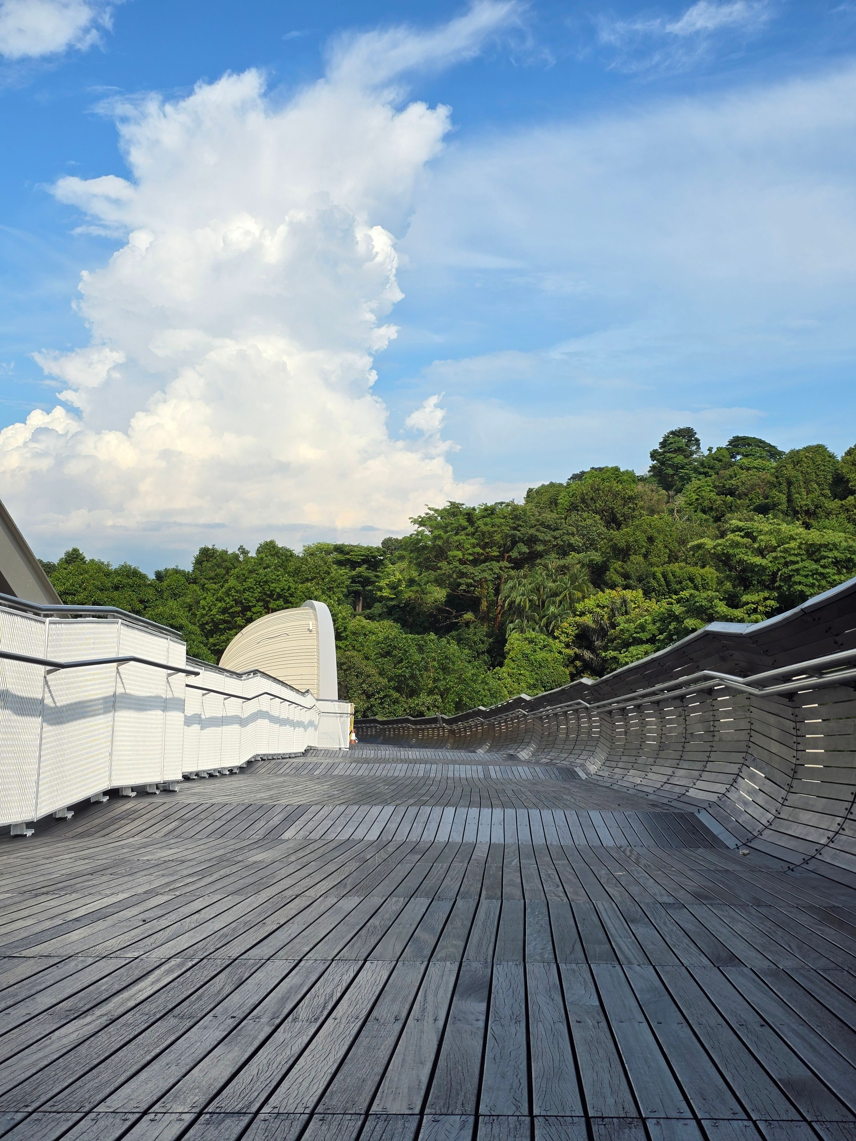
From Faber Point, the trail descends through woodland to Henderson Waves — a 274-metre pedestrian bridge standing 36 metres above Henderson Road. It is Singapore's highest pedestrian bridge, and its design is immediately recognisable: seven undulating steel ribs clad in yellow balau wood create wave-like curves that double as sheltered seating alcoves.
The bridge connects Mount Faber Park to Telok Blangah Hill Park. During the day, the curved ribs offer shade and harbour views. After 7 pm, LED lights illuminate the structure until 2 am, turning it into one of Singapore's most photogenic night walks. A nutmeg tree at the Mount Faber end marks the site of a former nutmeg plantation.
- Distance: 274 metres
- Time: 10–15 minutes (longer if stopping for photos)
- Tip: Visit between 6:30 pm and 7:30 pm to catch the transition from sunset to LED lighting — the best of both worlds.
Telok Blangah Hill Park — Hilltop Walk and Terrace Garden (1.7 km – 3.3 km)
After crossing Henderson Waves, you enter Telok Blangah Hill Park. The Hilltop Walk runs for about 1 km through the park's upper ridge, passing exercise stations, a vending machine, and a public toilet. The Terrace Garden — a series of semi-circular terraces on the hilltop — provides a near-360-degree panorama of the Singapore skyline and harbour. It's a popular wedding photography spot for good reason.
Along the way, look for the Sembcorp Forest of Giants, an arboretum of large native tree species planted to attract hornbills, fruit pigeons, and the greater racket-tailed drongo back to the area. The historic Alkaff Mansion, a restored colonial building, now houses a restaurant and bar with air-conditioned indoor seating — a useful mid-walk refuelling option.
- Distance: ~1.6 km
- Time: 30–40 minutes
- Facilities: Toilets, vending machines, Alkaff Mansion restaurant
Forest Walk and Alexandra Arch (3.3 km – 5.4 km)
Important update (as of early 2026): The eastern section of the Forest Walk is closed due to slope failure caused by heavy rains. Repair works are expected to be completed by July 2026. An alternative route along Depot Road or via the entrance opposite Block 88A at Telok Blangah Heights connects you to the Earth Trail to continue along the Southern Ridges. Check the NParks Telok Blangah Hill Park page for the latest status before your visit.
When open, the Forest Walk is a 1.3 km elevated walkway that passes through secondary forest at heights between 3 and 18 metres. It connects to Alexandra Arch, an 80-metre curved bridge designed to resemble an open leaf. Alexandra Arch crosses Alexandra Road and is lit with colour-changing LEDs at night.
- Distance: ~2.1 km (including alternative route if Forest Walk is closed)
- Time: 30–45 minutes
- Note: The alternative route includes stairs and road-level walking along Telok Blangah Heights
HortPark — Themed Gardens and Floral Walk (5.4 km – 6.5 km)
Alexandra Arch leads into HortPark via the Floral Walk, a 300-metre path lined with flowering plants. HortPark itself is a 23-hectare gardening hub with themed display gardens — including butterfly, Balinese, silver, and golden gardens — plus research greenhouses supplying plants to Gardens by the Bay.
This is a good place to pause. There's a café, shaded seating, and toilets. If you're walking with children, the themed gardens break up the walk nicely. From HortPark, a side trail also leads south to Labrador Nature Reserve — a worthwhile 2 km detour if you have time (see the Nearby Attractions section below).
- Distance: ~1.1 km
- Time: 20–30 minutes (longer if exploring gardens)
- Facilities: Café, toilets, sheltered seating, water
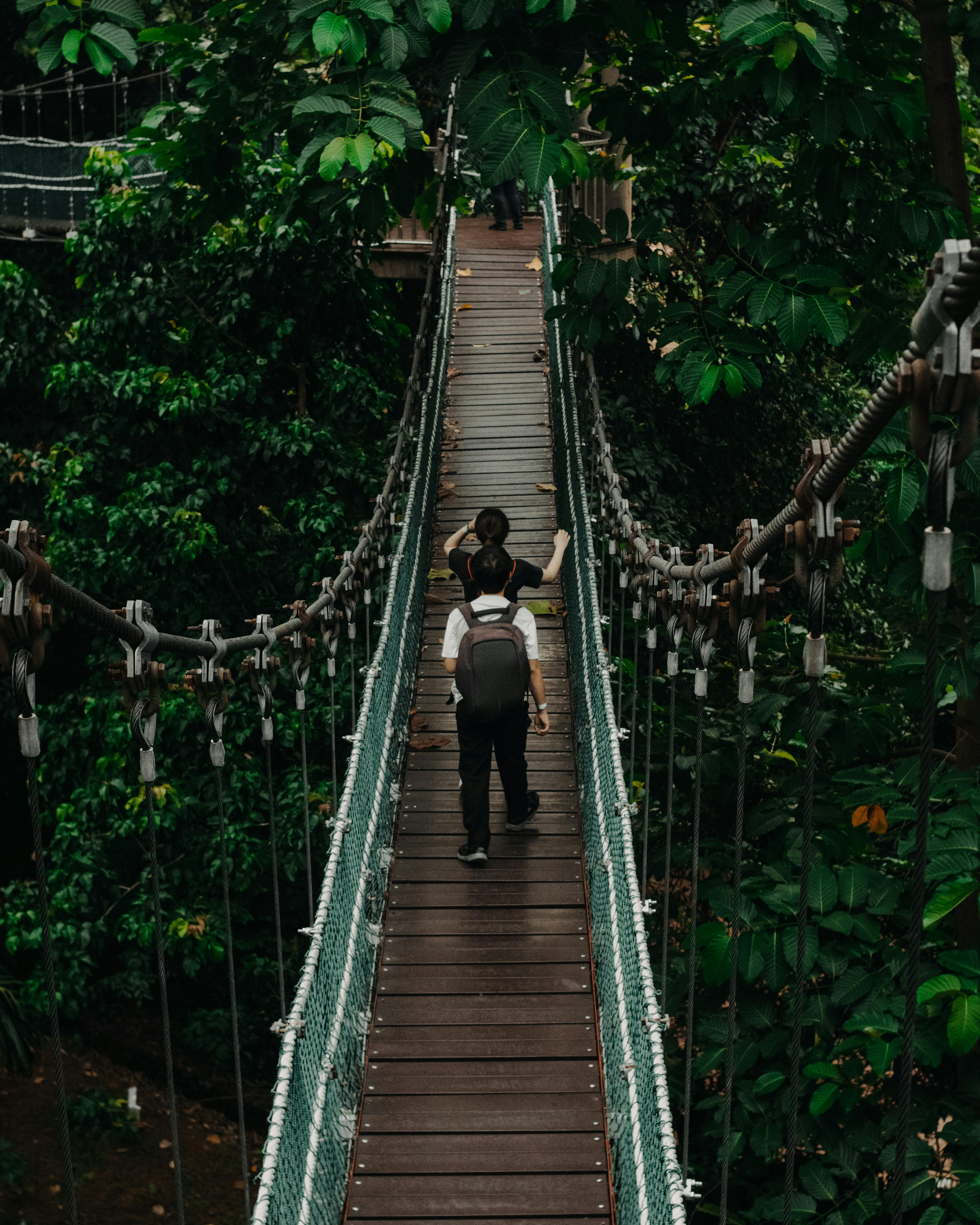

Canopy Walk and Kent Ridge Park (6.5 km – 10 km)
The Canopy Walk is a 300-metre elevated trail linking HortPark to Kent Ridge Park. Raised 16 metres at its centre, it passes through groves of tembusu trees and secondary forest — look for squirrels, sunbirds, doves, and white-crested laughing thrushes. It's a shorter, quieter echo of the Forest Walk, and one of the route's more peaceful stretches.
At the Kent Ridge Park end, Reflections at Bukit Chandu is a WWII interpretive centre housed in a colonial bungalow. The museum covers the Battle of Pasir Panjang (February 1942), when soldiers from the Malay Regiment made a fierce last stand against Japanese forces on this hillside. It's open Tuesday to Sunday, 9:30 am to 5 pm, with a small admission fee. Even if you skip the museum, the area around it — including old pillboxes and military markers — gives the walk a layer of historical weight.
The final stretch continues through Kent Ridge Park past the small Kent Ridge Pond and Dragonfly Pond before reaching the exit near Kent Ridge MRT station.
- Distance: ~3.5 km
- Time: 50–70 minutes
- Facilities: Toilets at Kent Ridge Park; museum café
Practical Details — Timings, Access, and What to Bring
The Southern Ridges walk requires no gear, no permits, and no entrance fee. But a few planning details make the difference between a comfortable walk and a sweaty slog.
Getting There by MRT and Bus
Both ends of the trail are served by MRT, making it easy to plan a one-way walk without retracing your steps.
- Eastern end (Mount Faber): HarbourFront MRT (NE1/CC29) — Exit D, then follow signs to Marang Trail (~10-minute walk to trailhead)
- Western end (Kent Ridge): Kent Ridge MRT (CC24) — Exit B, take Bus 92 for one stop to Block 85, then walk to Kent Ridge Park Pond
- Mid-trail access: Labrador Park MRT (CC27) provides access near HortPark and the Forest Walk section
- Bus option for Henderson Waves: Redhill MRT (EW18), then Bus 145 for 7 stops to "Bef Telok Blangah Hts"
Which Direction to Walk
Both directions work, but each has trade-offs:
- East to west (HarbourFront → Kent Ridge): Gets the steepest climb (Marang Trail) out of the way first when you're freshest. The final sections are gentle and downhill. This is the most popular direction.
- West to east (Kent Ridge → HarbourFront): Starts with the quieter Canopy Walk and builds toward Henderson Waves and the Mount Faber views as a finale. The Marang Trail descent at the end is steep on the knees.
What to Pack
The trail is urban and paved, but Singapore's heat and humidity demand preparation:
- Water: Bring at least 1 litre per person. There are no drink stalls between Mount Faber and HortPark — the longest gap on the route.
- Footwear: Closed-toe walking shoes or trainers with grip. The Marang Trail and some alternative routes have uneven steps. Flip-flops are not advisable.
- Sun protection: Sunscreen, a hat, and sunglasses. While much of the trail is shaded, the exposed sections — particularly Henderson Waves and the Hilltop Walk — can be intense in the midday sun.
- Rain layer: A lightweight poncho or compact umbrella. Afternoon thunderstorms are common year-round.
- Insect repellent: Useful in the forested sections, especially around dusk.
Toilet and Water Points Along the Route
- Faber Peak (restaurants + toilets)
- Telok Blangah Hill Park (public toilet near Hilltop Walk, vending machine)
- Alkaff Mansion (restaurant, air-conditioned rest stop)
- HortPark (café, toilets, sheltered seating)
- Kent Ridge Park (toilets near pond area)
Best Time to Walk the Singapore Southern Ridges
The trail is open 24 hours, but when you walk matters more than you might expect. Temperature, lighting, and crowd levels shift significantly across the day.
Time of Day
Early morning (7–9 am) is the best window. Temperatures sit around 25–27°C, the trails are quiet, and the light through the forest canopy is soft. You'll also have better chances of spotting wildlife — sunbirds, long-tailed macaques, and monitor lizards are more active in the cooler hours.
Late afternoon (4–6 pm) is the second-best option, especially if you want to catch sunset from Henderson Waves or Mount Faber. Time your walk so you reach Henderson Waves around 6:30 pm — you'll see the golden-hour light over the harbour and stay for the LED illumination that starts at 7 pm.
Midday (11 am – 3 pm) is best avoided. Even shaded sections feel oppressive in Singapore's tropical humidity, and exposed stretches like Henderson Waves and the Hilltop Walk get direct overhead sun.
Season and Weather
Singapore's tropical climate means heat and humidity year-round, but some months are more comfortable than others:
- February to May: Drier inter-monsoon period with slightly lower humidity — the most comfortable months for the walk.
- June to September: Southwest monsoon brings occasional haze from regional fires. Check the PSI (Pollutant Standards Index) before heading out.
- November to January: Northeast monsoon — the wettest season. Afternoon storms are frequent and trails can be slippery. The Forest Walk alternative route is particularly affected by wet conditions.
Weekday vs Weekend Crowds
Henderson Waves and the HortPark section draw significant weekend foot traffic, particularly on Saturday and Sunday mornings. Weekday mornings are noticeably quieter. If you're walking on a weekend, starting before 8 am gives you roughly an hour of relative solitude before joggers and family groups arrive.
Nearby Attractions to Combine with the Southern Ridges
One advantage of the Southern Ridges is its position between several other attractions. You can easily extend your walk into a half-day or full-day outing.
Sentosa via Cable Car from Mount Faber Peak
The Singapore Cable Car departs from Faber Peak, connecting to Sentosa Island in a roughly 15-minute ride over Keppel Harbour. If you start the Southern Ridges walk from HarbourFront, you can take the cable car up to Faber Peak to skip the Marang Trail climb, then walk the ridge westward. Alternatively, ride the cable car to Sentosa after finishing the eastern section of the trail.
Labrador Nature Reserve Detour
From HortPark, a park connector trail leads south to Labrador Nature Reserve — a roughly 2 km detour each way. The reserve includes Berlayer Creek, one of the last two remaining mangroves in southern Singapore. Highlights along the loop include the Dragon's Teeth Gate (a natural granite outcrop that once marked the entrance to Keppel Harbour), the Red Beacon (a former maritime navigational marker), and a coastal boardwalk with views of Reflections at Keppel Bay.
VivoCity and HarbourFront Post-Walk
If you end at HarbourFront MRT, VivoCity is directly connected — Singapore's largest waterfront mall. It's a practical option for a post-walk meal, with everything from hawker-style food courts to sit-down restaurants. The air-conditioning alone is a good reason to stop.
Tips for Walking the Southern Ridges
A few practical details that most guides don't mention — but that shape the actual experience on the trail.
Trail Tips at a Glance
- Download the NParks NEAR app before your walk — it has offline trail maps and park connector routes that help with navigation, especially around closures.
- Signage says "Henderson Waves" or "Faber Walk," not "Southern Ridges." Know your next landmark rather than looking for a single trail name.
- Wear light, moisture-wicking clothing. Cotton soaks through fast in Singapore's humidity. A sweat towel is worth packing.
- Start hydrated. Drink 500 ml of water before you begin, not just during the walk.
- If walking at dusk, bring a headlamp or phone torch. The Kent Ridge Park section is not fully lit after dark.
Wildlife to Look For
The Southern Ridges supports more biodiversity than you'd expect from an urban trail. NParks planted over 200 native tree species near Gillman Village specifically to attract native birds back to the area. Keep an eye (and ear) out for:
- Long-tailed macaques: Common around the Telok Blangah and Kent Ridge sections. Keep food stored away and don't make direct eye contact.
- Sunbirds and white-crested laughing thrushes: Best spotted early morning along the Canopy Walk.
- Monitor lizards: Occasionally seen crossing paths in the HortPark and Kent Ridge areas.
- Butterflies and dragonflies: Particularly abundant near HortPark's butterfly garden and Kent Ridge Pond.
Current Trail Updates
Trail conditions change periodically due to weather and maintenance. Before your visit, check the NParks website for the latest closure notices. As of early 2026, the Forest Walk remains closed for slope stabilisation works. A section of footpath below the Therapeutic Garden in Telok Blangah Hill Park is also closed for separate slope works. Both closures have signed alternative routes.
Plan Your Southern Ridges Walk
The Southern Ridges is one of the few places in Singapore where you can walk for three to four hours through forest canopy, across architectural bridges, and past WWII history — all without leaving the reach of an MRT station. It costs nothing, demands no special equipment, and works for solo walkers, couples, and families alike.
If you have time for only one outdoor walk in Singapore, this is the one. And if you're building a broader itinerary, the trail pairs well with a cable car ride to Sentosa, a morning at Labrador Nature Reserve, or an afternoon exploring the VivoCity waterfront.
Start planning your Singapore trip with Travjoy's curated selection of experiences — from nature walks to city tours, each one vetted by local experts. Explore Singapore on Travjoy.
.svg&w=1920&q=75)


